Aboriginals have inhabited the Australian continent for at least 40,000 years, but it’s a matter of debate which European nationality was the first to ‘discover’ Australia and put it on the map.

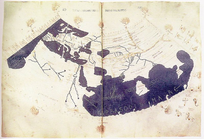
Ptolemy's World Map 150AD
Terra Australis Incognita ~ The Unknown Land of the South ~
appeared on Ptolemy’s maps, circa 150AD.
Ptolemy’s 8-book atlas ‘Geographica’ was the source of information upon which maps were based during the age of discovery in the late 1400 – 1500’s. It was with this limited data, which had changed little in nearly 1,500 years that sea explorers set off to ‘discover’ the world.
- Columbus setting off for India across the Atlantic in 1492 when he ‘discovered’ America
- Magellan, the Portuguese born, and Spanish national who’s crew made the first circumnavigation of the world via the Spice Islands in 1522, followed by
- Drake who was the first Englishman to circumnavigate in 1580.

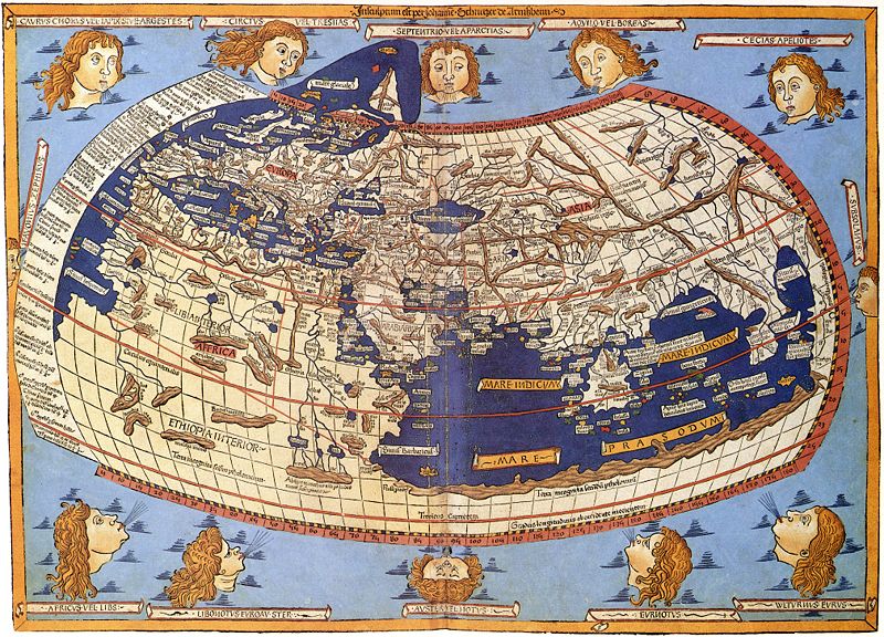
Woodcut of Ptolemy map by Johane Schnitze 1482
The first records of Europeans landing in Australia include:
- 1606 Willem Jansz, the first recorded Dutchman to set foot on the western shore of Cape York Peninsula.
- 1616 Dirk Hartog, the first Dutchman to set foot in Western Australia
- 1688 William Dampier was the first Englishman to visit Australia, yet…
- 1770 Captain Cook* [Editor’s note: see comments below] has the credit for officially claiming Australia in the name of the British.
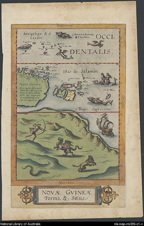
The map below is the first map from the western world depicting Australia and was published in 1593, prior to any of these official landings.
It shows the east coast of Australia with New Guinea to the north. The land hosts an archer taking aim at a griffin, which is a mythical creature with an eagle’s head and a lion’s body. A lion and writhing snake also inhabit the landscape.
This map ‘Novae Guineae Forma, & Situs’ was part of a major work entitled ‘Speculum Orbis Terrarum’
It had been initiated by Gerard de Jode (1509 – 1591) a Dutch born cartographer, engraver and publisher who died in Belgium leaving the atlas uncompleted. His son Cornelis de Jode (1568 – 1600) finally published the work 2 years after his father’s death in 1593.
With its whimsical sea monsters, mermaids, sailing ships & sense of discovery,
this would be one of my favourite antique maps 🙂
Postscript: 27.03.2011
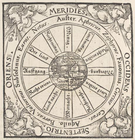
I am indebted to Peter Reynders whose comments below have drawn my attention to a map held by the National Library that illustrates the first known usage of the word ‘Australia’ on a German map dated 1545
Click here for more details 🙂


James Cook was the first Englishman to actually chart the entire east coast of Australia from south to its northern most tip – the 1598 map looks nothing like the east coast so it’s fairly safe to assume it’s not a cartographic representation. Cook was the first Englishman to bother “claiming” Australia for the British – our history says nowhere that he was the ONLY Englishman to come here – and why it was so unusual was because at the time he was only a Lieutenant – he wasn’t given the rank of Captain until his return to England.
Cool maps though!
Thanks so much for your comment ~
An estimated 54 European ships made contact with Terra Australis between 1606 and 1770
http://www.australiaonthemap.org.au/landings-list/
But it was George 111 who in 1768 sent, as you point out, Lieutenant Cook with secret instructions to take possession of ‘a Continent or Land of great extent”with the Consent of the Natives”in the Name of the King of Great Britain’
http://www.foundingdocs.gov.au/item.asp?sdID=67
Cartographers in the 16th century had to have creative imaginations to fill in all the unknown areas, which as you say in the case of the de Jode map, was most of it!
Hence its quirky charm today 😉
As Linda states above ( July 2009) the http://www.australiaonthemap.org.au website provides a landing list of mariners coming to various parts to Australia as ‘firsts’ much more complete than the 4 strangely selective dot points above.Indeed Dampier did not chart any coasts here that had not been charted before, whilst Australians named a State after Tasman, who he is not mentioned. Indeed most of them were captains of the VOC, the Dutch East-indies Company. Now that website has a new English translation of the first founding Charter of that Company that is most revealing. Linda also hints that 16th century maps were largely fantasies just extending s a few points to try and keep the Ptolomean “legends” or theories alive. These did however have no base in fact. That led to speculative theories about Portuguese and Chinese etc coming to Australia and Charting it before 1606. Yet all this speculative stuff keeps the attention on the Aussie maritime contact history. PR
The first Englishman to sail into Australian waters was EIC Captain John Brookes in 1622, Not William Dampier. Brookes was shipwrecked on Tryal Rocks West Australia in his ship the Tryal (seven years before the Eastindiaman Batavia (of mutiny fame) underwent to same fate) and he lost most of his crew, going then to (then) Batavia in a small launch with some survivers. The introductory text above could also have mentioned also the first Spaniard (Torres, 1606), the first Frenchman sailing into Aussie waters, the year before Dampier did and the Makassan Fishermen who also fished trepang at the Aussie Northcoast many years before Cook arrived.
The Aborigines ( yes THEY DID “discover” Australia) most likely crossed the more extensive stretches of sea on Tsunami flotsam about 49000 years ago in order to finally get here…. as watercraft had not been invented yet and the ones that developed between 10-20.000 years ago were only dveloped for and used in calm streams and rivers. They were not sea-going craft. (there are other theories but these have been debunked) The oldest watercraft found in peat & preserved is the Canoe of Pesse, now in the Museum at Assen.
Thank you so much Peter for your valuable input here 🙂
As the title may indicate, this post was not so much about the discovery of Australia, as to briefly illustrate the first renditions of Australia on maps, which I found interesting as they were produced before any of the official European landings.
I’d recommend anyone who is after a detailed list of official landings on Australian shores to refer to the link I posted in a previous comment:
http://www.australiaonthemap.org.au/landings-list/
I learnt and now added a postscript to the above post illustrating the first known use of the word ‘Australia’ in any context that dates from 1545. 🙂
O yes Linda, I failed to raise this with you: Cook claimed only the east coast of the continent for Britain, not ‘Australia, and of course did not chart the east coast of Tasmania, = part of the east coast of Australia.
Are you doing something special to commemorate the visit of Dirk Hartog next year, then 400 years ago? Socially perhaps?
Peter Reynders
It should provide the perfect excuse to head west, really, shouldn’t it?!
I see all sorts of commemorations are being planned at least for Denham!
And exciting the replica ‘Duyfken’ will be sailing the coast re-enacting the landing 🙂
What are you planning on doing?!!